Environmental Protection Regulation 2008

Where do EHP's roles apply in wetland regulation?
The Department of State Development, Infrastructure and Planning (DSDIP) is an assessment manager or referral agency for a development application for material change of use, reconfiguring a lot or operational works involving high impact earthworks (as defined in the Sustainable Planning Regulation 2009) in wetland protection areas. High impact earthworks include the construction of new drains, placing of fill or construction of levies in a wetland protection area that significantly alter the hydrology of a wetland.
The Department of Environment and Heritage Protection (EHP) is a technical agency and may be requested to provide advice to DSDIP about these proposals. For more details about the assessment process, visit the DSDIP website.
What happened to EHP's referral agency advice role for wetland management areas?
Local governments have been advised that there is no longer a requirement to refer development applications to EHP for advice on impacts in wetland management areas, shown on the map of referrable wetlands. In August 2012, this requirement was removed by the Sustainable Planning Amendment Regulation (No. 5) 2012. In the near future the map of referrable wetlands will be amended to remove the wetland management areas.
What type of development is assessed by SDAP Module 11?
SDAP Module 11 regulates new development proposed in a wetland protection area (WPA) within GBR catchments involving high impact earthworks. Examples of high impact earthworks include draining and filling of wetlands and works such as diversions, which change the hydrology of wetlands, introduce pollutants, or increase the amount of sediment flowing downstream. High impact earthworks are defined under Schedule 26 of the Sustainable Planning Regulation 2009.
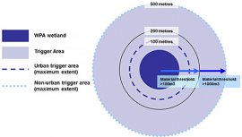
Development for a material change of use, reconfiguration of a lot(s) (subdivision) or operational works involving high impact earthworks in, or partly within a WPA are assessable under the Regulations. The associated assessable development triggers can be found in Schedule 3, part 1 of the Sustainable Planning Regulation 2009.
How do high impact earthworks damage wetlands?
The main threat to wetlands is lack of water. High impact earthworks affect the hydrology of a wetland, that is, how the water flows in and out. Any draining or work that reduces the amount of water in a wetland threatens the functioning of that wetland.
High impact earthworks can damage wetlands and the habitats around them by:
- changing the hydrological regime by altering water levels and environmental flows
- removing vegetation and fauna habitat, and reducing ecological integrity
- facilitating the introduction of pest animals and plants
- introducing pollutants
- accelerating soil erosion and sediment run-off.
When is an environmental offset required?
Where adverse effects from development within a wetland protection area in an urban area cannot be avoided, those effects are minimised and offset.
Offsets are also required in circumstances where development does not need to fully achieve the policy outcome including: providing for an overriding need in the public interest, for a development commitment, or for certain types of community infrastructure.
However there are limited circumstances where a development commitment arising from and necessary to give effect to a development approval is not required to provide an environmental offset for residual adverse impacts on high ecological significance wetlands.
Who is affected by the new Regulations?
Landholders, urban developers or primary producers who want to carry out high impact earthworks that might affect a WPA wetland have to make an application through the Integrated Development Assessment System (IDAS). See the definition of high impact earthworks in Schedule 26 of the Sustainable Planning Regulation 2009 (PDF).
What is the application fee?
The fee schedule for development applications involving operational work, reconfiguring a lot or a material change of use of premises in a Great Barrier Reef wetland protection area is set out in Schedule 10, part 2, item 5 of the Environmental Protection Regulation 2008 (PDF).
How can I find out if a wetland is protected?
You can find out if the wetland policy covers your property by requesting a map from the map of referable wetlands. The map of referable wetlands identifies WPAs within the Great Barrier Reef catchments regulated under the SDAP Module 11.
You will need to know the property description (lot on plan) details of your property to find out if a wetland on your property is a referable wetland.


